Where should NYC’s next Wi-Fi hotspot be?

With the start of the COVID-19 pandemic, access to the internet became an even more essential amenity than before. Not having ready access to fast internet creates significant hardship in a world where many adults are expected to be working from home, doing more business online, and children are going to school virtually. Therefore, it is all the more important that NYC prioritizes the implementation of its first-in-the-nation Internet Master Plan for universal broadband coverage (announced Jan 7, 2020). Until that plan is realized, work/study-from-home New Yorkers currently without home internet access rely on mobile internet connection and public Wi-Fi hotspots, such as those provided by the Link NYC kiosks, public libraries, and NYC partner organizations.
In this blog post, I take a look at the spatial distribution of home internet access and existing public Wi-Fi locations to make recommendations about where the next batch of hotspots should be deployed to reach the people who could benefit the most. My methodology and next steps are briefly covered at the end of the post.
Percentage of Households with No Internet Access, by Community District

There are 18 community districts (shown in black above) where over 20% of the households do not have internet access. The lowest access levels are in districts 312 and 201, where 32% and 31% of households don’t have internet access, respectively. 312 is in Brooklyn, covering the neighborhoods of Borough Park, Kensington, and Ocean Parkway. 201 is in the Bronx (neighborhoods Mott Haven, Port Morris, Melrose).
Now, let’s see where the public Wi-Fi hotspots are located- ideally, they should be in the black areas!
Public Wi-Fi Hotspots and Percentage of Households with No Internet Access, by Community District

Not quite. Looks like most of the hotspots are in Manhattan, in the “white” areas where most households already have internet. This is strategic to help out tourists and commuters who are likely to spend most of their time in the these areas. Of course, in the world of pandemic induced stay-at-home orders, these hotspots might not be of the most help to New Yorkers.
Looking at the above map, I thought the hotspots were creating shapes vaguely similar to the map of the subway lines, so I decided to add that layer on.
Public Wi-Fi Hotspots, Subway Lines, and Percentage of Households with No Internet Access, by Community District
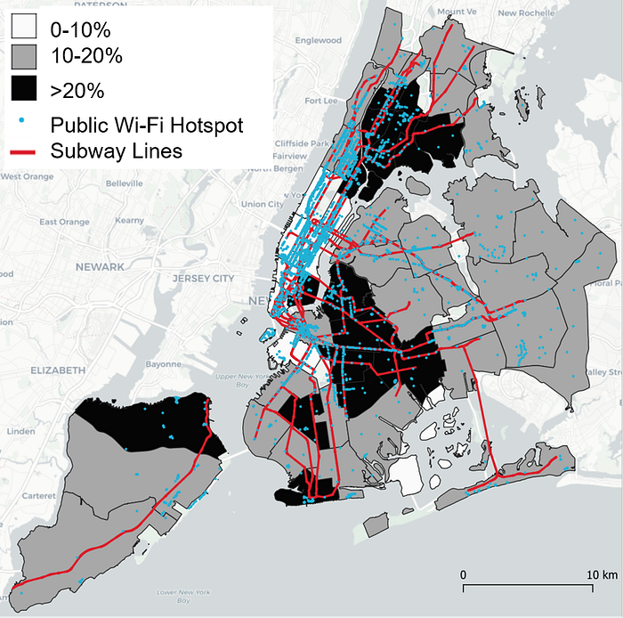
I wasn’t wrong! Upon doing a quick analysis in QGIS, I found that 10% of the hotspots are actually right on subway platforms. This makes sense considering the MTA’s partnership with Transit Wireless, a communications company, which led to the installation of free Wi-Fi at 281 subway stops. While this is great for commuters, given that many of us are no longer commuting, train internet just isn’t as helpful as the closer-to-home variety.
To ascertain where more hotspots should be installed, I looked at the density of hotspots by the population residing within each district.
Areas with Low Public Wi-Fi Hotspot Coverage Layered Over Percentage of Households with No Internet Access, by Community District
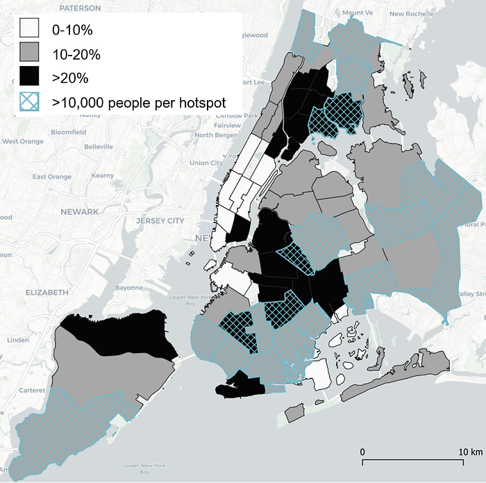
What we see here is that there are five community districts where the black and the blue hatch overlap, meaning that in these five districts more than 20% of households don not have internet access and there are more than 10,000 people per hotspot.
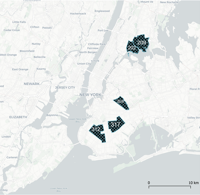
I would propose these areas for deploying Wi-Fi hotspots.
Proposed Locations for New Public Wi-Fi Hotspots
(the numbers on each district stand for that district’s name)
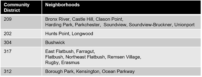
The below table lists the neighborhoods covered by each of the five districts.
Neighborhoods by Community District
More nuanced analysis should be done to narrow down which of these neighborhoods would benefit most from the addition of public Wi-Fi hotspots, but this list is good place to start.
Methodology
For this analysis I used datasets from NYC Open Data and the Pratt Community Center for Neighborhood Development. I used QGIS v. 3.10.10 for analyzing the data and creating the maps, and PowerPoint to add the legend to the maps.
I began with the Community Districts spatial map from the Pratt Center and joined it with the csv data set containing information on household level internet access (Internet Masterplan Broadband Adoption by Community District, from NYC Open Data). After performing the join, I made a choropleth map showing the distribution of households with no internet access. I chose 3 categories (0–10%, 10–20%, and >20%) based on reviewing the data (range: 6%-32%). Next, I added the location of the Wi-Fi hotspots as a second layer (NYC Wi-Fi Hotspot Locations, NYC Open Data). Upon noticing the pattern reminiscent of the subway map, I added the subway line layer (Subway Lines, Pratt Center). To calculate what percentage of the hotspots are located on the subway, I created a 20 ft buffer around the subway lines and selected the hotspots that intersected this buffer layer.
To bring population into the mix, I used one of the Pratt Center’s demographics datasets based on the U.S. Census Bureau’s 2014–2018 American Community Survey 5-Year Estimates. The population data was provided at the census tract level, so I had to perform a spatial join between the community district layer containing the internet information and the population layer. I performed a spatial join by summary, summarizing the total population for the census tracts that intersected a given community district. Once I had this new layer, I created a new field to represent hotspot density, where I divided the total population of a district by the number of hotspots in that district. Then, I experimented with classification levels and different visual approaches for displaying this information overlaid with the household internet information. To obtain the final map showing the five districts where I recommend the placement of new hotspots, I filtered the layers I was working with to the districts where high rates of no internet access coincided with low hotspot coverage.
Conclusion and Next Steps
Based on my analysis, I recommend that NYC prioritizes the deployment of additional public free Wi-Fi infrastructure to the five community districts shown in the last map (202, 209, 304, 312, and 317). To narrow down where public internet access could be most beneficial, additional analysis is necessary. For example, more granular, building-level internet access data would be helpful. Obtaining this data could be challenging, given that there are multiple internet service providers with franchise in the city. Then, I would conduct a survey to find out how people who do not have internet access at home are coping with the demands of the digital age during the pandemic to better ascertain if public Wi-Fi hotspots are a reasonable short-term substitute for universal broadband coverage. I would focus the survey on the districts identified by this analysis to get a sense for the local needs and behavioral patterns around internet usage. This information would be beneficial in deciding where and how to deploy additional internet resources.
